RHUBARB PARADISE
I remember discovering the Faroe Islands on the world map as a child. A subdivision of the Danish kingdom located in the middle of the Atlantic Ocean, somewhere between Iceland, Scotland and Norway. It piqued my curiosity, but it stopped there. If you wanted to know more about something in the pre-Google era, you had to go there, and I had no mandate to do so back then. It took nearly four decades before the Faroes were put back on my mental map. Very specifically by my travel-hungry better half. A few years ago she had already visited the islands with her brother and sister. This time we are planning to go with our small family unit. A full week of hiking in rugged nature. Finally we can do this again, pandemically speaking. We are looking forward to it.
One thing before we take off. According to Wikipedia, the Faroes are blessed with a “mild maritime climate.” Despite its northern location, it is rarely really cold. And, for now, they don’t really experience heat here at all. So not a word is lied about this mildness. But at the same time it is a hilarious euphemism. For what is mild about storms and rain every day? Someone wrote that the Faroe Islands’ greatest export product is low-pressure areas. Low pressure areas, that’s a meteorologic synonym for shitty weather. Now, our loyal followers know that we don’t let a few rain clouds stop us. In fact, secretly we love them. But be warned if you book a trip to the Faroe islands yourselves: those who can’t deal with extremely mild weather will go nuts here.
Late Saturday night we land on Vágar, the westernmost of the larger islands. As long as the trip took – including an hour-long layover in Copenhagen – just as short is the runway. Imagine, the runway was once even shorter; in 2011 it was extended from 1250 to 1799 metres. Size matters for runways, no doubt about that. But I think there is also a psychological effect at play here. At Schiphol Airport, you are under the illusion that your plane can roll on into the countryside should the pilot have a bad day. Here, the runway ends at the edge of a cliff. That leaves little room for illusions. Fortunately, today we have a pilot who does what he has to do.
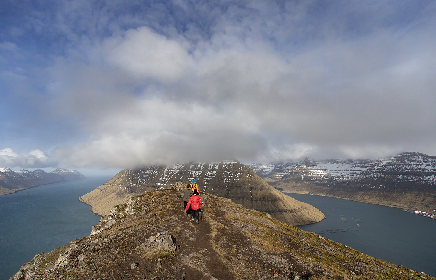
Ellen has rented a nice little apartment for the first night, just a 15-minute drive from the airport. We receive a warm welcome, there is coffee waiting for us and delicious rolls for breakfast. To add to the party, the sun shines brightly the next morning. A godsend, as you’ll have gathered by now. We get into our car as fast as we can and drive to the southern tip of Vágar for our first hike. It’s not an overly strenuous hike; we need to start this action-packed vacation slowly. Steadily we trudge up the trail. To our right is Sørvágsvatn, an elongated lake that extends just offshore. The fact that the lake is at a higher level than the sea creates a beautiful visual effect, like a natural infinity pool. To our left, after about an hour, a panorama unfolds that will give you goosebumps – if not from the view, then at least from the history. We are standing in front of a hundred and forty-metre deep abyss that ends perpendicularly in the ocean. Trælanípa is the name of this cliff: Faroese for Slave Cliff. The Vikings used to push their disobedient slaves off it. The wind is so strong that we carefully avoid the edges of the cliff. Meanwhile, the sun shines – I repeat: an exceptional gift in this extremely mild climate zone.
Back at the car, we learn that we should have paid two hundred Kroner to do this hike. Two hundred Kroner per person – that’s over a hundred euros for our small family. When we started hiking this morning, the clerk in charge was still lying on one ear. That has changed now. He is awake. And he is looking at us with a stern look. What is the protocol for undeclared hikers? Make them pay after all? Throw them off the cliff? His negotiating position sucks. He can hardly let us un-see the view or un-walk the walk. And after all, he himself was late this morning. He seems to realise this and lets us go. These steep hiking fees were instituted fairly recently, we learn from posts on travel forums. And they are mildly controversial. As a guest, you don’t have much to say about them. But we don’t regret getting up early this morning.
Famished after such an incredible hike, we plunge into lunch at Fiskastykkið. I order a bowl of mackerel and a rhubarb juice. It tastes sublime. Some say this is the best restaurant on the Faroes. It feels premature to peak at the very first restaurant of the vacation; ideally you build up to something like this. But the pleasure is not any less.
We are moving eastward, crossing the bridge that connects Vágar with Streymoy, the largest island in the Faroes. In Streymness we have rented an exceptional accommodation for the next two nights: an old boathouse. From way up high, we are looking out over the water – the narrow strip of sea between Streymoy and Eysturoy, the second-largest island. The wooden walls of our house squeak and creak under the strong wind. An extensive collection of electric heaters keeps us comfortable inside.
Island hopping is very easy on the Faroe Islands: a few kilometres north of our boathouse lies the bridge connecting Streymoy and Eysturoy. We make a day trip to Gjógv, a fishing town at the very top of Eystoroy. It lies in a natural harbour formed by a steep gorge – Gjógv means gorge in Faroese. On the way to Gjógv, we have a spectacular hike in mind. There is some snow on the road here and there. And the wind is quite strong, or should I say stormy? The starting point of the hike is on top of a mountain pass. Ellen and I get out of the car, deliberately one at a time, otherwise the car turns into a wind tunnel. We come to the conclusion that this is not going to work out. It’s too much like a blizzard, this is gonna hurt.
We drive on, and after some effort we find a passable road down to Gjógv. From there we hike to the top of the cliff. Again, it takes effort not to be blown off our socks. In this case that sounds more dangerous than it is, because we are strolling across a wide, boggy meadow. Only the last bit toward the summit gets a little too wild. But even beneath the summit we have nothing to complain about in terms of the view, especially when the sun peeks through the clouds.
On Tuesday morning we move to Klaksvík on the island of Borðoy. Klaksvík is a fishing town with five thousand inhabitants. Note that this makes it the largest town on the Faroe Islands after Tórshavn. Thanks to the Norðoyatunnilin that was opened in 2006 (a tunnel, 6 kilometres long and 150 metres below sea level), this crossing is also a piece of cake. We have now arrived in the north-eastern part of the Faroe Islands. On the map, this part of the archipelago strongly resembles an endoplasmic reticulum. If only you would have paid more attention in biology class, right?
We have some time to kill in Klaksvík before we can check in. Well, kill? Live! The plan is to hike to Klakkur, a peak to the west of the bay. According to eyewitness accounts, phenomenal views of several islands wait for us up there. According to those same statements, this hike falls into the ‘low effort, high reward’ category. The first part is not very interesting; we drive the car as far as possible on a gravel path uphill, until the snow prevents us from going any further. There we park the car and continue hiking the trail, until we reach a water reservoir. There is a layer of ice on the water. From that spot on, the wind suddenly gets free reign. Fortunately, we have hats, gloves, rain gear and windbreakers with us. But then an enormous hailstorm hits us. Crouched down, we wait for the downpour to pass, our heads tucked away in our hoods. It takes about 15 minutes until the hail stops, but the storm remains. We decide this is beyond our control. The mild weather has nipped our hike in the bud. We walk back to the car and treat ourselves to some small-town pleasures: a nice lunch, an investment in the local brewery (Föroya Bjór), a few hours of swimming in the indoor pool, and a wonderfully comfortable apartment called Brekkustova.
The next day the weather conditions are a tad more favourable. We consider a hike on the other side of Klaksvík but, after much deliberation, decide to make a second summit attempt on yesterday’s route. Tessel is struggling mentally. The surface on the second part of the route is rather soggy, which makes for tough walking. And the wind is still strong. But perseverance wins; this time we manage to complete the hike. The view is indeed a tremendous reward for the effort. It’s incredible on the top of Klakkur.
After lunch we take a little road trip to Borðoy’s neighbouring islands: Kunoy and Viðoy. Kunoy lies west of Borðoy and is connected by a few hundred-metre dam. There are two settlements on Kunoy: Haraldssund on the east coast and Kunoy “city” on the west coast. The former has a population of 69, the latter 64. There is only one road on the island – you guessed it: the road from Haraldssund to Kunoy “city”. The largest part of that road is a tunnel, right through the mountain ridge that dominates the island. So you could call it a near-private tunnel – how luxurious is that? Not surprisingly, they went for a one-lane tunnel. A very narrow, three-kilometre-long, self-regulating single-lane tunnel. One direction is allowed to drive through while the other, where necessary, takes evasive action in a lay-by to give way. The risk of such a construction is that, like a mediocre baseball player, you race nervously from lay-by to lay-by, your gaze fixed on the light on the horizon. Is that the end of the tunnel, or is it an oncoming car? To make it all even more exciting, a bus line also seems to operate here. It brings back memories of a somewhat panicked tunnel experience of ours, years ago in New Zealand, in the Milford Sound. After the first metres in the tunnel, in pitch darkness, we began to seriously doubt whether the headlights of our thirty-year-old van were functioning. I consider myself fortunate that Ellen was – and is – behind the wheel. Chez nous, driving is a female superpower.
That last bit, by the way, is quite appropriate: Kunoy is Faroese for Woman’s Island. According to some people, this name refers to a fishing accident on Christmas Eve 1913. In that accident, the island’s third village lost its entire male work force – seven souls – after which the women decided to dissolve the village and join Haraldssund. The story is probably true, but the island’s name will be older. The more likely explanation for the name Women’s Island is an alleged female-shaped rock formation on the north coast. Anyway, we didn’t verify this. After our tour of Kunoy, we drive to Viðareiði on Viðoy. Again, this island can be reached by a short dam. And here too is a single-lane tunnel, albeit with the luxury of a traffic light regulating the direction of travel. That’s quite relaxing.
It is Thursday. The nice weather that has prevailed so far has run out. It is drizzling. But no worries, we have a travel day. We will drive back to Streymoy, the main island. There, at the southern tip, we will board a ferry to the more southern island of Sandoy in the afternoon. A few days ago we made the crossing from Streymoy to Esturoy over a short bridge. Today, we take the tunnel – Eysturoyartunnilin – a bit further south. This brand new tunnel (opened in December 2020) not only connects two islands. It also connects two places on Esturoy that are less than a kilometre apart, but separated by a long deep bay. So it is a tunnel with three entrances – and with the world’s first undersea roundabout. As if that were not impressive enough, it also looks beautiful, with a lot of artful lighting. There is no shortage of tunnel vision here!
On the way to the ferry, we pause in Tórshavn, the capital. It should be clear by now that you should not expect a metropolis here. With a population of thirteen thousand, Tórshavn is the largest town on the Faroe Islands. The harbour looks picturesque, with pastel-coloured houses and a pier hosting red wooden government buildings. We drink coffee and rhubarb cheesecake there, and decide that the Faroe Islands is not only a nation of tunnel magicians but also a rhubarb paradise.
Before boarding the ferry, we take a look at nearby Kirkjubøur, a medieval settlement, and once the seat of the Faroese bishop. There is a house from the 11th century on this spot, one of the world’s oldest inhabited wooden houses. This is extra special since hardly any trees grow on the Faroe Islands. People had to manage with washed-up wood.
Two nights we spend on Sandoy. We stay in Peddastova, a charming cottage from the year 1902, right next to the ferry landing in Skopun. In the middle of the living room, a few hoops hang from the ceiling, so we can make a bird’s nest. Life is a party! The next day, from Skopun, we drive to Dalur, a place that can only be reached by a narrow coastal road along steep cliffs. It’s spectacular, but not for the fearful. From Dalur, we hike up a mountain towards the southern tip of the island. The road ascends quite steeply. The view is a bit disappointing due to the clouds, so we skip the last part. Seven kilometres is enough for today. The children need, as we call it, a rösti-day – a day of rest.
On Saturday, we take the ferry back to Streymoy. Ferry crossings on small islands are sometimes a bit exciting. Does the ferry sail today? Is the timetable correct? Is there room on the small ferry? And in this case: do we have a reservation or not? Ellen is not sure; doubt sets in. It wouldn’t be the first time our holiday schedule is thrown into disarray by a missed ferry crossing. Especially since we are getting on the plane the next day, we don’t want any trouble. To our relief, we are able to drive onto the ferry. Inside is inside; they surely won’t throw us off in the middle of the sea. However, when we walk back to the car, there appears to be a wheel clamp on our car. Shit, have we been branded as freeloaders after all? Or is the toll clerk from the Vágar hike claiming his hike tax after all? A Faroese man wearing a yellow vest clarifies matters. Our car did not seem to have the handbrake on properly, and to avoid damage they fixated the car. They are heroes! We thank him from the bottom of our hearts and find out how our (electronic) handbrake works the day before we return the hire car. Better late than never.
Before heading to Tórshavn we drive around southern Streymoy, until snow on the road halts us. We don’t have snow chains, and have no ambition to drive in snow anyway. In Tórshavn, we visit the sea aquarium. It’s small but nice, equipped with a ‘touch tank’ where you get to hold critters like sea urchins, starfish and shellfish for a while. (Online, I read an argument that this is not OK, since those critters have not given their consent to do so. Touché.)
To end the holiday in style, we have dinner on Saturday night at Haedd, a restaurant that claims to combine classic French cuisine with “Nordic fresh produce”. That promises something special and refined. But our overall verdict is that mainly the prices are haute at Haedd – the cuisine is fine but nothing special. So this is what you get when you visit the best restaurant at the very beginning of your holiday. I had warned ourselves.
Stijn
We have listed some hikes that are great to do with children: easy hikes on the Faroe Islands