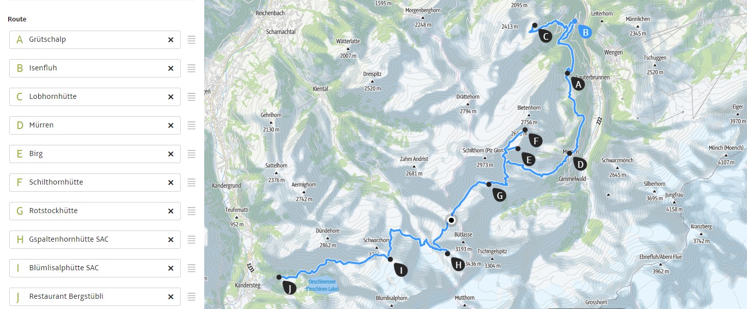
From Lauterbrunnen to Kandersteg in Switzerland – 6 days
Level: T2/T3
Period: End June – mid September
This is not a hut hike for beginners, especially the parts to the last two huts are tough. An easier version is the Hut-tohut around Mürren hike. Hiking times mentioned below are adjusted to hiking with kids.
Day 1: This day begins with taking the gondola from Lauterbrunnen to Grütschalp. From Grütschalp you have 2 options to get to the Lobhornhütte (1955m):
Option A (with a gondola ride): Hike from Grütschalp to Isenfluh – 4,7 km, 1:45, ↑ 190 m, ↓ 405 m – level T2. Then take the gondola from Isenfluh to Sulwald Stübli and hike on to the Lobhornhütte – 2,9 km, 2:00, ↑ 450 m ↓ 60 m – level T2. Sulwald Stübli is a very nice place to have lunch.
Option B: Hike from Grütschalp via Flöschwald and Kübodmen to the Lobhornhütte (1955m) – 6,9 km, 4:00, ↑ 770 m, ↓ 310 m – level T2.
Day 2: Hike from the Lobhornhütte to Grütschalp, via Kübodmen and Flöschwald, , a route that winds through peaceful forests and opens up to spectacular valley views – 6,9 km, 3:30, ↑ 310 m, ↓ 770 m – level T2. The trainstation in Grütschalp has a very nice cafetria to have lunch. You can also charge your devices in this cafeteria.
Upon arriving in Mürren, a car-free alpine village, take the gondola up to Birg (2684m), a high-altitude station with beautiful vistas. From here, a short but scenic descent leads you to the Schilthornhütte (2432 m), perched above the valley with a dramatic mountain backdrop – 3 km, 1:00, ↓ 270 m, ↑ 50 m – Level T2.
Day 3: Schilthornhütte hike to the Rotstockhütte (2040m) – 7 km, 3:00, ↑ 300 m, ↓ 700 m – level T2/T3.
Today’s route is both breathtaking and adventurous. The path winds through rugged mountain terrain as you make your way towards the Rotstockhütte (2040m). The descent from the sadle below Birg is really steep in some sections, offering thrilling yet manageable challenges for those comfortable with alpine trails.
Alternative for day 3: Hike back to station Birg. Take the gondola to Piz Gloria (2973 m). Take the gondola back to Birg and hike to the Rotstockhütte (2040m) – 7 km, 3:30, ↑ 350 m, ↓ 750 m – level T2/T3. It is also possible to desend from Piz Gloria, but this is only for true mountain goats, it’s a level T3/T4 hike.
Day 4: Rotstockhütte (2040m) to the Gspaltenhornhütte (2455m) – 6,6 km, 5:30, ↑ 950 m, ↓ 560 m – via the Sefinafurgga (2612m) – level T3, with some ladders and cables at the Sefinafurgga – level T3.
Leaving the Rotstockhütte, the trail climbs steadily through lush alpine meadows, with views of the Eiger, Mönch, and Jungfrau behind you. As you gain elevation, the landscape becomes more rugged, transitioning to rocky terrain as you approach the Sefinafurgga Pass (2612 m). This saddle, perched between the Lauterbrunnen Valley and the remote Kiental, offers sweeping panoramic views of the surrounding peaks. The descent from the pass is more technical, featuring ladders and cables to navigate steeper sections. Once past these obstacles, the trail meanders through a high alpine basin before reaching the Gspaltenhornhütte (2455 m), with an incredible view of the towering Gspaltenhorn (3436 m).
Day 5: Gspaltenhornhütte (2455m) to the Blümlisalphütte (2834 m) – 7 km, 6:00, ↑ 1000 m, ↓ 600 m – level T3.
Today’s trail climbs steadily through remote, rugged terrain. You’ll traverse steep scree slopes and barren rock fields, surrounded by glaciated peaks. As you ascend, the imposing Blüemlisalp Glacier comes into view. The final push to the Blümlisalphütte (2834 m), that sits at the very edge of the glacier, is demanding.
Day 6: Descend from the Blümlisalphütte (2834 m) to bergstation Oeschinensee (1682m) – 7,6 km, 4:00, ↓ 1250 m, ↑ 100 m – level T2/T3 . Take the gondola down to Kandersteg and take the train back to Lauterbrunnen (2 hours).
The trail leads down from the Blümlisalphütte, zigzagging through rocky alpine landscapes before transitioning into meadows. As you descend, you’ll see the Oeschinensee, one of the most stunning mountain lakes in Switzerland, its turquoise waters framed by dramatic cliffs and waterfalls. The final stretch is an easy, scenic walk along the lake’s edge before reaching the Bergstation Oeschinensee (1682 m). From here, a gondola ride takes you down to Kandersteg, where you’ll catch the train back to Lauterbrunnen (2 hours).
The huts can be booked online using Alpsonline.org.